25 July 2008

A Question of Providence: Line 207 Phase II — 2040

Providence is the name the City of Calgary has given to the six square miles of undeveloped lands on the city’s southwest flank that will by 2040 have “reached full development and [comprise] six vibrant and successful communities with 78,000 residents” (City of Calgary, 2006d:11). The city’s “Southwest Regional Policy Plan” anticipates the development of a dedicated bus corridor to “[provide] efficient and direct connections to the LRT further to the east” (2006d:11), but in light of existing long-range plans by the city to construct a southern peripheral light rail connector to the east of Line 201 — to say nothing of the construction of the first phase of Line 207 posited in this document — the most reasonable plan involves constructing an extension of Line 207 to Providence as a means of leveraging the investment already made in its first phase. Moreover, the recently annexed southeastern residential lands beyond the East Freeway Extension corridor will be ready by 2040 for a mass transit connection also, which lends credence to an extension of Line 207 to those nascent areas of the city as well.

The Providence Extension will proceed from the metro interchange at Somerset/Bridlewood Station through a short underground portal to a dedicated surface right of way in the median of 162 Avenue SW, running 800 metres to Shawinigan Station, at the intersection with Shawinigan Drive SW. From there, the line will continue 1,500 metres to James McKevitt Station, and a further 1,300 metres to Bridlecrest Station, at the junction with 24 Street SW. The line will then cross Sarcee Trail and arrive after travelling 1,500 metres at Sarcee Gate Station, where 162 Avenue meets the current 37 Street SW right of way, and then continue 1,700 metres to Providence Centre Station, at the intersection with 53 Street SW, before ending after a final 1,600-metre run at West Providence Station, where 162 Avenue meets 69 Street SW.

The lands to the east of the metro interchange at Auburn Bay Station are sufficiently uncharted to warrant a nod to the works of the speculative fiction master Isaac Asimov in christening the eastward continuation of Line 207 the Foundation Extension for the purposes of this discussion, and the names for the stations to be built will derive from the pages of that mid-twentieth-century trilogy. The Foundation Extension will continue underground generally to the east for 1,600 metres, beneath the planned community of Mahogany and the East Freeway Extension corridor, before surfacing for a 400-metre run to Trantor Station. At that point, the line will curve to the south, proceeding 1,600 metres to Kalgan Station, a further 1,600 metres to Anacreon Station, and a final 1,800 metres to the aptly named Terminus Station.

The total capital investment required for the Providence phase of Line 207 comes to $771-million, a figure that could be carried over thirty years in instalments of $39-million from 2041 onward, or financed through an MSI-equivalent funding mechanism from 2038 to 2040 in three instalments of $257-million. The details of the necessary capital investment are identified as follows:

Providence Surface Track and Way of 6.40 km
@ $25-million per km: $160-million
plus six surface stations (Shawinigan, James McKevitt, Bridlecrest, Sarcee Gate, Providence Centre, West Providence)
@ $10-million each: $ 60-million


Foundation Metro Track and Way of 1.60 km
@ $155-million per km: $248-million


Foundation Surface Track and Way of 5.40 km
@ $25-million per km: $135-million
plus four surface stations (Trantor, Kalgan, Anacreon, Terminus)
@ $10-million each: $ 40-million


Rolling Stock of 32 LRVs (Avanto)
@ $4-million each: $128-million

While Providence will see the greatest immediate benefit from the second phase of Line 207 construction, there are a number of additional advantages that apply to this C-Train extension well beyond that district’s boundaries. By interchanging both with Line 201 and Line 203, the completed Line 207 will afford mobility opportunities to Calgarians who desire convenient mass transit access to residential, retail, and commercial destinations across the city’s southern flank. In Providence specifically, the proposed development of local employment centres that “will create local and regional job opportunities and are integral to the operation of the transportation network” (City of Calgary, 2006d:27) and “centrally-located, pedestrian-oriented and mixed use” core commercial centres (2006d:28) will enhance the effectiveness of Line 207 by providing public transportation for area residents and by offering a useful range of services for passengers from outside the area who wish to conduct business with Providence’s professionals and entrepreneurs. Where the greatest opportunity arises, perhaps, is in the as-yet unplanned residential lands to be served by the Foundation Extension, where the opportunity to work from the proverbial blank slate and apply best practices in transportation and transit-orientated development from Calgary and elsewhere is too profound to go unheeded.


Works Cited

City of Calgary (2006d). "Southwest Regional Policy Plan". URL as of 20 Mar 2008 http://www.calgary.ca/DocGallery/BU/planning/pdf/sw_regional_plan/southwest_regional_policy_plan_one.pdf

A Question of Providence: Line 207 Phase I — 2038

The City of Calgary’s existing long-range plans for mass transit expansion include a light rail corridor integrated with a segment of the southern arc of the Transportation and Utility Corridor, the land reservation in which provincial Highway 22X runs, although the “Chaparral Area Structure Plan” takes pains to note that conceding that these long-range plans exist “[does] not imply a commitment to construct the LRT to serve Chaparral or any other community south of Midnapore” (City of Calgary, 1988a:5). While a four-lane motorway with plans for its widening would not be the first choice of location for most observers looking for places to put light rail stations, the existence of the Transportation and Utility Corridor does at least provide a direct route which, with judicious use, would ease the implementation of a light rail connection between the C-Train’s south and southeast legs. Where the challenge lies is in bringing enough of this connection to within a reasonable distance of its users to make it convenient to use in the broader context of future extensions bringing a wider variety of passengers and key destinations into the line’s range.

The initial phase of Line 207 would start from a metro interchange with Auburn Bay Station on Line 203, and proceed generally to the northwest for 500 metres underground before emerging onto a surface right of way within the Transportation and Utility Corridor and continuing for 3,300 metres to Cranston Station, at the Highway 22X interchange with Cranston Boulevard SE, and for a further 2,500 metres to Chaparral Station, slightly east of the interchange with Chaparral Boulevard SE. The line would then cross Highway 22X and enter a dedicated surface right of way in the median of Sun Valley Boulevard SE, travelling 3,600 metres to Midnapore Station, at the junction with Midlake Boulevard SE, and a further 1,200 metres to an underground portal crossing beneath Macleod Trail South and arriving after a 500-metre run at a metro interchange with Somerset/Bridlewood Station on Line 201.

The total capital investment required for the first phase of Line 207 comes to $830-million, a figure that could be carried over thirty years in instalments of $42-million from 2039 onward, or financed through an MSI-equivalent funding mechanism from 2036 to 2038 in three instalments of $277-million. The details of the necessary capital investment are identified as follows:

Marquis of Lorne Metro Track and Way of 1.00 km
@ $155-million per km: $155-million
plus two metro stations (Auburn Bay, Somerset/Bridlewood)
@ $92-million each: $184-million


Marquis of Lorne Surface Track and Way of 9.00 km
@ $25-million per km: $225-million
plus three surface stations (Cranston, Chaparral, Midnapore)
@ $10-million each: $ 30-million


Corridor Yard: $200-million


Rolling Stock of 32 LRVs (Avanto)
@ $4-million each: $128-million

Although accommodations for connecting transit routes, passenger parking, and pedestrian access to light rail stations are to varying degrees limited in the design of this initial phase of Line 207, it nevertheless offers some critical advantages to the communities it is intended to serve. Phase I provides additional connectivity to the C-Train network as a whole by providing a direct link in the southern reaches of Calgary between Lines 201 and 203, and brings the formerly isolated communities of Chaparral and Cranston into an at least tangential connection to the city’s mass transit network. Also, by utilising a reasonable mix of in-median service through Midnapore and Shawnessy in conjunction with a surface right of way “in an easterly direction along the south side of Marquis of Lorne Trail” (City of Calgary, 1988a:5), this initial phase splits the proverbial difference between serving passengers with readily available access and taking advantage of readily available rights of way adjacent to Highway 22X. The primary benefit of the first phase of Line 207, however, is that it provides a central arterial starting location from which it becomes possible to build more effective connectivity and more robust ridership in the implementation of Line 207’s second phase.


Works Cited


City of Calgary (1988a). “Chaparral Area Structure Plan”. URL as of 26 Mar 2008 http://www.calgary.ca/docgallery/bu/planning/pdf/chaparral_asp.pdf

24 July 2008

An Old Connection and a New Edge City: Line 206 Phase II — 2039

With the bulk of the time and effort in constructing Line 206 already accomplished in its initial phase, further extensions to the east and west could be accomplished with substantially less effort, and with substantial network-wide benefits. To the west of Bowness lie Canada Olympic Park, a complex of athletic facilities maintained in the wake of the 1988 Olympic Winter Games, and the residential community of Valley Ridge, a lower-density development designed to accommodate 6,000 residents upon its completion (City of Calgary, 1991:4). To the east, on the other hand, lies the bedroom community of Chestermere, a rapidly expanding town whose current population of 10,000 is projected to rise to 15,000 by 2010 and to 24,000 by 2015 (Bunt and Associates, 2007:21), and of whose residents nearly two-thirds — 65.7 percent of 1,264 respondents in a recently commissioned survey (Town of Chestermere, 2008:19) — commute to Calgary for their regular employment. Serving this broad mix of mature and emerging residential populations is an eminently reasonable use of mass transit in the broader context of a long-range light rail service plan for Calgary.

The eastern extension of Line 206 would be a relatively simple affair, proceeding in a dedicated surface right of way in the median of 17 Avenue SE for 1,100 metres from Forest Lawn Station to Elliston Park Station, at the intersection with 61 Street SE, and then for 3,800 metres to Garden Road Station and for 3,200 metres to Rainbow Road Station, before terminating at a 2,000 metre distance at Chestermere Station, at the junction with West Chestermere Drive. While the western extension of Line 206, on the other hand, would be somewhat more complex, it would be eminently feasible to continue from Bowness Station along Bowness Road NW to 83 Street NW, tunnelling under 16 Avenue NW to arrive after 1,500 metres at Canada Olympic Park Station before continuing on an alignment on the southern flank of the Transcanada Highway and tunnelling underneath it once more to terminate after a distance of 2,600 metres at Valley Ridge Station, where Valley Ridge Boulevard meets Valley Ridge Drive NW.

The total capital investment required for the final buildout of Line 206 comes to $593-million, a figure that could be carried over thirty years in instalments of $30-million from 2040 onward, or financed through an MSI-equivalent funding mechanism from 2037 to 2039 in three instalments of $198-million. The details of the necessary capital investment are identified as follows:

Bowness/Forest Lawn Metro Track and Way of 1.00 km
@ $155-million per km: $155-million


Bowness/Forest Lawn Surface Track and Way of 10.00 km
@ $25-million per km: $250-million
plus six surface stations (Valley Ridge, Canada Olympic Park, Elliston Park, Garden Road, Rainbow Road, Chestermere)
@ $10-million each: $ 60-million

Rolling Stock of 32 LRVs (Avanto)
@ $4-million each: $128-million

As beneficial as this second and final phase of Line 206 will be to destinations on the west side of Calgary, the merits of its eastward continuation to Chestermere are clearer still. The new station at Canada Olympic Park is situated to take maximum advantage of the core commercial planning area as identified in the “Canada Olympic Park and Adjacent Lands Area Structure Plan” by connecting C-Train passengers with the pedestrian facilities within that sector (City of Calgary, 2005a:14). Furthermore, the central location of the new station at Valley Ridge will minimise the “topographic constraints” inherent to the area that would otherwise compromise the provision of connecting transit services to local area residents (City of Calgary, 1991:33). Those points being made, the advantages of the westward extension of Line 206 pale in comparison to those of providing C-Train service to Chestermere: In an environment where 77.5 percent of 1,307 survey respondents either somewhat or strongly supported the expansion of roadway and public transit networks in Chestermere (Town of Chestermere, 2008:14), and in a municipality facing daily traffic of 21,000 vehicles through Highway 1A, its primary traffic artery, in a mere seven years (Bunt and Associates, 2007:27), it should come as little surprise that 56.3 percent of 1,340 survey respondents would be open to the sort of “apples and oranges” mix of residential uses (Town of Chestermere, 2008:11) that would make transit-orientated development, and by extension the long-range provision for light rail service, a viable possibility for Chestermere to the benefit of town residents and Calgarians alike.

Works Cited
Bunt and Associates Engineering (Alberta) Ltd. (2007). “Town of Chestermere transportation Study: Final Report — Part One”. URL as of 24 Jul 2008 http://chestermere.ca/images/uploads/Planning_TofC_Transportation_study_Part_one_smaller_version.pdf
City of Calgary (1991). “Revised Valley Ridge Area Structure Plan”. URL as of 26 Mar 2008 http://www.calgary.ca/docgallery/bu/planning/pdf/valley_ridge_asp.pdf
City of Calgary (2005a). “Canada Olympic Park and Adjacent Lands Area Structure Plan”. URL as of 26 Mar 2008 http://www.calgary.ca/docgallery/bu/planning/pdf/canada_olympic_park/canada_olympic_park_asp_one.pdf
Town of Chestermere (2008). “Community Survey Summary”. URL as of 24 Jul 2008 http://chestermere.ca/images/uploads/TOC_SurveySummary_05152008.pdf

An Old Connection and a New Edge City: Line 206 Phase I — 2037

Calgary’s connections to the formerly sovereign town of Bowness date back almost a century to 1911, when developer John Hextall donated the current Bowness Park lands and built a bridge over the Bow River in exchange for a tram line to Calgary (City of Calgary, 1995a:7). Bowness would join the towns of Montgomery and Forest Lawn in amalgamating with the City of Calgary in the 1960s, but their distinct identities, their responsiveness to public transportation, and their at times vexing proximity to major roadways leading to the east and west from the boundaries of the unified city give them common ground nearly fifty years onward. In the interest of enhancing the special relationship Calgarians share with these formerly independent communities, and with the aim of strengthening the efficiency and the vitality of their transit connections, Line 206 will strike most observers as a particularly useful addition to Calgary’s light rail transit network.

The initial phase of Line 206 would commence at Bowness Station, a surface level platform at the intersection of Bowness Road and 77 Street NW. From there, the line would proceed in a dedicated surface right of way along Bowness Road NW, travelling 3,600 metres to Montgomery Station, at the junction with 46 Street NW, and then 1,600 metres to Point McKay Station, at the intersection with Point Drive NW, and a further 1,400 metres to a grade-separated interchange with Line 204 at Parkdale Station. At that point, the line would follow Parkdale Avenue and Kensington Road NW for 1,200 metres to West Hillhurst Station, where Kensington Road meets 22 Street NW, and for another 1,100 metres to Westmount Station, at the intersection with 16 Street NW. Line 206 would then enter an underground portal to tunnel underneath 14 Street NW and the Bow River, travelling south and east for 1,100 metres to arrive at Armoury Station, a metro interchange with 11 Street Station on Line 202 located between Eighth and Ninth Avenues SW just east of 11 Street SW. Proceeding from that location underneath Ninth Avenue SW, Line 206 would continue underground for 500 metres to Eighth Street Station; for 400 metres to Fifth Street Station, interchanging with Line 201; for 300 metres to Third Street Station, forming the southern pole of an interchange complex with Lines 201, 202, and 203; for 400 metres to Palliser Station, interchanging at that location with future commuter rail services; and for 800 metres to Edmonton Station, interchanging with Olympic Way Station on Line 203 and with future high-speed rail services. Line 206 would then cross underneath the Elbow River to emerge in a dedicated surface right of way in Ninth Avenue SE and travel for 1,600 metres in total to New Street Station, at the intersection with 13 Street SE, before continuing for 2,600 metres along the southern flank of Blackfoot Trail and then across it to Riverside Quays Station, at the junction of 17 Avenue and 17A Street SE. From that location, Line 206 would bridge the Bow River and Deerfoot Trail SE, travelling through a short underground portal to surface in a dedicated right of way in the median of 17 Avenue SE, proceeding for 2,000 metres to Radisson Heights Station, at the intersection with 31 Street SE, and then for 1,400 metres to 44 Street Station before ending 800 metres east of 44 Street SE at an underground interchange with Forest Lawn Station on Line 204.

The total capital investment required for the initial phase of Line 206 comes to $2,074-million, a figure that could be carried over thirty years in instalments of $104-million from 2038 onward, or financed through an MSI-equivalent funding mechanism from 2033 to 2037 in five instalments of $415-million. The details of the necessary capital investment are identified as follows:

Bowness/Forest Lawn Metro Track and Way of 4.00 km
@ $155-million per km: $620-million
plus eight metro stations (Parkdale, Armoury, Eighth Street, Fifth Street, Third Street, Palliser, Edmonton, Forest Lawn)
@ $92-million each: $736-million

Bowness/Forest Lawn Surface Track and Way of 12.00 km
@ $25-million per km: $300-million
plus nine surface stations (Bowness, Montgomery, Point McKay, 29 Street, West Hillhurst, Westmount, New Street, Riverside Quays, Radisson Heights, 44 Street)
@ $10-million each: $ 90-million

Hubalta Yard: $200-million
Rolling Stock of 32 LRVs (Avanto)
@ $4-million each: $128-million

In addition to enhancing the connectivity of the C-Train network within the downtown core and to restoring and improving historical transit linkages to Montgomery, Bowness, and Forest Lawn, the initial stage of Line 206 will generate additional redevelopment benefits within these communities. As a case in point, the “Montgomery Area Redevelopment Plan” highlights the “strategic importance” of the intersection of Bowness Road and 46 Street NW, the intended location of Montgomery Station, to “the objective of encouraging a transition to a pedestrian friendly mixed use (commercial/residential) area” (City of Calgary, 2005b:4). In a similar vein, the construction of Bowness Station at Bowness Road and 77 Street NW would be useful in the context of mitigating the “negative influence on the surrounding area” resulting from current land uses on the Bow Centre site (City of Calgary, 1995a:49) and improving the quality and the density of residential and commercial uses on the site. Perhaps the most profound improvement opportunity arising from the building of Line 206, though, would be the restoration of 17 Avenue SE as a retail and residential corridor, based on activities dating to 2004 engaging local residents and business owners with the aim of transforming the thoroughfare as far east as Rainbow Road “into high density, mixed use environments that utilize existing infrastructure” (T-Six Urbanists Inc., 2008:11).

Works Cited

City of Calgary (1995a). “Bowness Area Redevelopment Plan”. URL as of 26 Mar 2008 http://www.calgary.ca/docgallery/bu/planning/pdf/bowness_arp/bowness_arp_one.pdf

City of Calgary (2005b). “Montgomery Area Redevelopment Plan”. URL as of 26 Mar 2008 http://www.calgary.ca/DocGallery/BU/planning/pdf/montgomery_arp/montgomery_arp_one.pdf

T-Six Urbanists Inc. (2008). “Profile: January 2008”. URL as of 24 Jul 2008 http://www.tsix.ca/images/TSixProfile-Jan08lr.pdf

23 July 2008

Connecting the C-Train to the World: Line 205 — 2033

The concept of connecting international airports to the downtown cores of Canadian cities has long since escaped the realm of mere fancy. Blue 22, the proposal for a premium-fare commuter rail service between Toronto’s downtown Union Station and Pearson International Airport “designed to complement existing transit services by attracting additional ridership to both the Toronto Transit Commission's and GO Transit's services” by removing as many as 10,000 vehicles per day from the Toronto road network (Queen’s Printer of Canada, 2006), has been on and off the proverbial drawing board since 2003. A downtown-to-airport commuter railway is also in the early discussion stages in Montréal, where The Montréal Gazette’s Henry Aubin reports that the federal and provincial governments are awaiting a consultants’ report this autumn to determine the viability of such a connection (Aubin, 2008). In Vancouver, conversely, the Canada Line light metro connecting downtown Vancouver and the southern city of Richmond anticipates the need for a four-station spur line connecting to Vancouver International Airport by the end of 2009 as something of an ancillary benefit to a mass transit service plan for an urban corridor that is “home to one-third of the region's jobs and 20 percent of its population.…[and] experiences the greatest traffic density and associated problems” (Canada Line Rapid Transit Inc., 2008). The challenge in Calgary’s context is to take advantage of Calgary International Airport’s relative proximity to its downtown while taking maximum advantage of the mass transit tools already in place and creating the least reasonable disruption to transportation and development corridors already in place, and on the basis of the work this document envisions accomplishing to this point, a partial orbital light rail line that interchanges with existing radial lines and also serves airport traffic is the ideal solution to the problem.

Starting from a metro interchange with Line 202 at 88 Avenue Station, Line 205 will follow an underground arc of 800 metres to surface east of 52 Street NE in the Airport Trail median and proceed a further 1,200 metres to arrive at Jacksonport Station, serving that commercial development midway between Métis Trail and 36 Street NE. From there, the line will continue for 2,300 metres in the Airport Trail median underneath the new runway and across Barlow Trail NE before arcing through an underground portal and tunnelling 500 metres to the airport terminal building at YYC Station, before continuing underground an additional 500 metres back to Airport Trail and emerging in that roadway’s median once more to arrive after travelling 400 metres at Stoney Park Station, where Airport Trail intersects 15 Street NE. Line 205 will then proceed westward 1,600 metres, crossing Deerfoot Trail in the Airport Trail median, to Deerfoot Bluffs Station, interchanging at that location with future commuter rail services using the Canadian Pacific Railway corridor, and continue 1,800 metres west to an underground interchange with Aurora Park Station on Line 203. After proceeding 900 metres along Country Hills Road and Country Hills Drive NW to Panorama Crossing Station, at the junction of Country Hills Boulevard and Country Hills Drive NW, Line 205 will continue west in the median of Country Hills Boulevard for 2,300 metres to reach 14 Street Station, and a further 1,500 metres with a southbound turn through a short underground portal into the median of Shaganappi Trail NW to MacEwan Station, where Shaganappi Trail meets the Macewan community pathway. At that point, Line 205 will travel 1,700 metres in the Shaganappi Trail median to Edgemont Station, at the junction with Edgemont Boulevard NW, and a further 2,200 metres to John Laurie Station, at the intersection with John Laurie Boulevard NW, before continuing 700 metres to Northland Village Station, where Shaganappi Trail meets Dalhousie Drive NW, and terminating after a final 700-metre run at Shaganappi Trail Station, a new grade-separated interchange facility connecting Line 205 to Line 201.

The total capital investment required for the full buildout of Line 205 comes to $1,386-million, a figure that could be carried over thirty years in instalments of $69-million from 2034 onward, or financed through an MSI-equivalent funding mechanism from 2031 to 2033 in three instalments of $462-million. The details of the necessary capital investment are identified as follows:

Airport Metro Track and Way of 2.40 km
@ $155-million per km: $372-million

plus four metro stations (88 Avenue, YYC, Aurora Park, Shaganappi Trail)
@ $92-million each: $368-million

Airport Surface Track and Way of 9.10 km
@ $25-million per km: $228-million

plus nine surface stations (Jacksonport, Stoney Park, Deerfoot Bluffs, Panorama Crossing, 14 Street, MacEwan, Edgemont, John Laurie, Northland Village)
@ $10-million each: $ 90-million

Stoney Park Yard: $200-million

Rolling Stock of 32 LRVs (Avanto)
@ $4-million each: $128-million

The Calgary Airport Authority anticipated the need for a light rail connection in its 2004 “Calgary International Airport Master Plan”, wherein a Public Transport Interchange immediately adjacent to the airport terminal would function as “a convenient interchange between surface access modes and the passenger terminal system” and consolidate public transit access to the airport “in a single area with a separate access system….[to] relieve congestion on the departures roadway” (Calgary Airport Authority, 2004:10-5–10-6). In addition to providing this mass transit alternative for Calgarians seeking access to the Calgary International Airport, Line 205 provides a method for transit passengers in the northern areas of the city to connect to three of the C-Train’s radial lines, as well as to a future commuter rail hub, while still making use both of available median rights of way and of the light rail corridor protected in the “Aurora Business Park Area Structure Plan” to serve both “a wide range of industrial uses” and “office and retail use as well as hotels and motels serving the Calgary International Airport” (City of Calgary, 2008a:23). What Line 205 provides is a robust and effective means of connecting airport passengers, airside and landside commercial and industrial employees, and leisure transit users alike to a city-wide light rail network serving the downtown core and all points beyond — thus bringing the world to the C-Train’s rails in one fell swoop.

Works Cited

Aubin, Henry (2008). “Light at end of the track”. The Montréal Gazette. URL as of 23 Jul 2008 http://www.canada.com/montrealgazette/news/sports/story.html?id=e251c9de-e833-49ad-b13b-468dcaffc7e4

Calgary Airport Authority (2004). “Calgary International Airport Master Plan 2004”. URL as of 26 Mar 2008
http://www.calgaryairport.com/fts/getfile.cfm?FID=3947

Canada Line Rapid Transit Inc. (2008). “Canada Line: Meeting Long-Term Needs”. URL as of 23 Jul 2008 http://www.canadaline.ca/aboutNeeds.asp

City of Calgary (2008a). “Aurora Business Park Area Structure Plan” URL as of 26 Mar 2008 http://www.calgary.ca/DocGallery/BU/planning/pdf/aurora_asp/aurora_asp.pdf

Queen’s Printer of Canada (2006). “Transport Minister Announces Winning Proposal for Toronto Air-Rail Link”. URL as of 23 Jul 2008 http://www.tc.gc.ca/mediaroom/releases/nat/2003/03-h132e.htm

22 July 2008

Expanding from a New Model: Line 204 Phase IV — 2031

With the previous three phases of Line 204 construction, a number of essential destinations in Calgary, ranging in scope from residential and retail services on the one hand to commercial, institutional, and industrial locations on the other, will be accessible to light rail transit services by direct connections and through interchanges with all three radial lines emanating from the downtown core. The only piece left in the puzzle will be that of creating a central loop that travels through all of the cardinal points in the circle to generate a complete bidirectional path across all of Calgary’s primary flanks. On the basis of the remaining termini on Line 204 — namely, Foothills Medical Station on the northwest end, and College Station on the southwest end — the 37 Street SW alignment suggests itself as a direct solution to the problem, worthy of the capital investment required on that basis alone, and one that also addresses the only orbital-to-radial light rail interchange left isolated from the core C-Train system at this juncture.

Starting from the Phase III terminus at College Station, Phase IV would continue underground to the northwest, running roughly beneath 45 Avenue SW to arrive after 400 metres at Glamorgan Station, where 37 Street SW meets Grafton Road. From there, the line would continue under 37 Street SW for 800 metres to Rutland Park Station, at the intersection with Richmond Road SW, and from there for 700 metres to Killarney Station, at the junction with 26 Avenue SW, before proceeding an additional 1,200 metres to jog slightly to the northeast and interchange with Line 202 at Westbrook Station. At that point, the line would work its way underneath Bow Trail and Spruce Drive SW for 1,200 metres to reach Spruce Cliff Station, at the intersection of Spruce Drive and Third Avenue SW, before descending to cross the Canadian Pacific Railway tracks, the Lawrey Gardens Natural Area, and the Bow River to arrive after 900 metres at Parkdale Station, at the intersection of Parkdale Boulevard and 29 Street NW, before proceeding generally underneath 29 Street NW for 1,200 metres to close the Line 204 circle at Foothills Medical Station.

The total capital investment required for the final buildout of Line 204 comes to $1,672-million, a figure that could be carried over thirty years in instalments of $84-million from 2032 onward, or financed through an MSI-equivalent funding mechanism from 2028 to 2031 in four instalments of $418-million. The details of the necessary capital investment are identified as follows:

37 Street Metro Track and Way of 6.40 km
@ $155-million per km: $992-million

plus six metro stations (Glamorgan, Rutland Park, Killarney, Westbrook, Spruce Cliff, Parkdale)
@ $92-million each: $552-million

Rolling Stock of 32 LRVs (Avanto)
@ $4-million each: $128-million

Aside from the immediate benefits of directly connecting the pre-existing northwest and southwest termini of Line 204 and of integrating the western leg of Line 202 into the resulting completely orbital light rail line, a number of ancillary benefits will also come into play with the full buildout of Line 204. All of the stations to be built between Mount Royal College and the south bank of the Bow River complement and respect the development and traffic management aims for the neighbourhoods to be served by the western arc of Line 204, with the Rutland Park and Killarney stations in particular reinforcing the objectives of the “Killarney Area Redevelopment Plan” to provide convenient access into and out of the community, discourage shortcuttingtraffic and minimize the negative traffic impacts resulting from new development” (City of Calgary, 1986c:27-28). At the same time, the connection across the Bow River to Parkdale and the Foothills Medical Centre will afford new opportunities for the Parkdale community to generate transit-orientated linkages “to surrounding communities, the regional pathway system, local and regional parks, transit stops and pedestrian crosswalks” (City of Calgary, 2004a:28) while respecting local sentiment favouring “pedestrian-orientated scale and massing” and Parkdale Boulevard’s role “as a gateway to Calgary” (2004a:28-29). Perhaps the most important effect of finishing the Line 204 loop, however, will be its ability to redistribute overall gains in passenger traffic to the broad benefit of the C-Train system as a whole; as the Madrid Public Transport Authority's Carlos Cristóbal-Pinto noted in his 2003 case study of the Madrid Metro, the completion of Madrid's orbital Line Six led to immediately discernable passenger redistribution effects in conjunction with a five-year rise of 22.5 percent in system-wide passenger levels (2003:6), indicating "big demand growth without any repercussions on peak hour" headway efficiency (2003:10). For all of these reasons, completing the western arc of Line 204 represents a substantial investment paying all the more substantial dividends for mass transit passengers and for all Calgarians.

Works Cited

City of Calgary (1986c). “Killarney/Glengarry Area Redevelopment Plan”. URL as of 26 Mar 2008 http://www.calgary.ca/docgallery/bu/planning/pdf/killarney_arp.pdf

City of Calgary (2004a). “Parkdale Special Planning Study”. URL as of 26 Mar 2008 http://www.calgary.ca/DocGallery/BU/planning/pdf/parkdale_special.pdf

Cristóbal-Pinto, Carlos (2003). “Madrid Case Study: Last Stretch of Metro Line 6,
Circle Line”. URL as of 22 Jul 2008
http://www.boku.ac.at/verkehr/05_05_Madrid_CRTM.pdf

Expanding from a New Model: Line 204 Phase III — 2029

One of the sudden and surprising flashpoints in the debate over Calgary’s future as an urbane and sustainable metropolis has been the fate of the Calgary Farmers’ Market on the site of the former Canadian Forces Currie Barracks. Although it is the stated aim of the 200-acre site’s owner, the Crown-administered Canada Lands Company, and of city planners alike to transform the location into “a richer mix of land uses, housing types, and servicing innovations to achieve a more complete community” (Canada Lands Company, 2008:2), a report from The Calgary Herald’s Sean Myers would suggest that in spite of the Calgary Farmers’ Market operating for as few as three days a week, any contemplation of permitting it to decamp from the Currie Barracks upon the October 2009 expiry of its lease "would be a crime," in the words of at least one regular customer interviewed for Myers’ story, on the grounds that "this place is a destination" for Calgary residents and visitors alike (2008:B2). Yet the Calgary Farmers’ Market is but one of several commercial and residential targets along the southern flank of Calgary’s core — along with such locations as the Deerfoot Meadows retail complex and Mount Royal College, as cases in point — that simultaneously are poorly served by previous plans for mass transit in the city and are prime targets for site-specific intensification as Calgary evolves into a more vibrant and viable urban form, and it will be one of the destinations that stands to benefit greatly from a substantial but strategic capital investment in a light rail connector route that brings all of these key destinations into the orbit of an increasingly robust city-wide mass transit network.

Starting from the Phase II terminus at Ogden Station, Phase III would continue underground east by southeast, running for a portion of the route directly beneath Jack Setters Park, for about 1,600 metres before bridging the Bow River and settling into a surface right of way at Heritage Meadows Way SE, proceeding a total of 1,300 metres further to arrive at Deerfoot Meadows Station, where Heritage Meadows Way intersects 11 Street SE. From there, the line would continue across Heritage Drive SE to Heritage Gate and enter an abandoned railway corridor before rising to meet 58 Avenue SE, arriving after a total of 1,800 metres to the intersection with Burbank Road SE at Burns Industrial Station, and then proceeding a further 800 metres along 58 Avenue SE to arrive at Manchester Station, where 58 Avenue intersects Third Street SE. At a westward distance of 300 metres from that location, the line would enter a portal and curve south by southwest below grade for 900 metres before arriving at a metro interchange with Chinook Station on Line 201; from there, the line would curve west and continue underground for 1,200 metres to Mayfair Station, beneath the intersection of Elbow Drive and Malibou Road SW, and then proceed a total of 2,400 metres on a line following the Glenmore Causeway and descending to a route paralleling the western shore of the Glenmore Reservoir to arrive under the intersection of 54 Avenue and 19 Street SW at Glenmore Park Station. The line would continue north by northwest from there for 1,600 to arrive at Garrison Circle Station, beneath the roundabout at Garrison Boulevard and Flanders Avenue SW, before crossing underneath Crowchild Trail SW for 700 metres to Currie Station, at the junction of Caen Avenue and Quesnay Wood Drive SW, and proceeding a further 900 metres to reach its Phase III terminus at College Station, underneath the existing Calgary Transit terminal at the west gate to the Mount Royal College complex.

The total capital investment required for the Glenmore phase of Line 204 comes to $2,250-million, a figure that could be carried over thirty years in instalments of $113-million from 2030 onward, or financed through an MSI-equivalent funding mechanism from 2026 to 2029 in four instalments of $563-million. The details of the necessary capital investment are identified as follows:

Glenmore Metro Track and Way of 8.00 km
@ $155-million per km: $1,240-million

plus six metro stations (Chinook, Mayfair, Glenmore Park, Garrison Circle, Currie, College)
@ $92-million each: $ 552-million

Glenmore Surface Track and Way of 4.00 km
@ $25-million per km: $ 100-million

plus three surface stations (Deerfoot Meadows, Burns Industrial, Manchester)
@ $10-million each: $ 30-million

30 Street Yard: $ 200-million

Rolling Stock of 32 LRVs (Avanto)
@ $4-million each: $ 128-million

The capital investment in Phase III of Line 204 is warranted for a number of reasons related to mass transit enhancement and community building. In the first instance, this third phase of Line 204 would thoroughly address and build upon the aspirations of the "CFB West Master Plan", which anticipates "improved service, in the form of longer hours and more frequent service to Parade Square, Mount Royal College and other activity areas", the Calgary Farmers' Market among them, in conjunction with enhanced connections to Chinook Station and the downtown core and with effective transit circulation within the Currie Barracks lands (City of Calgary, 2000:163). Furthermore, this phase affords a valuable and useful mass transit alternative with city-wide light rail connectivity for a Deerfoot Meadows retail and commercial complex that identifies an employee, customer, and visitor throughput of 120,000people per day (Ivanhoe Cambridge, 2008). In addition, this alignment is compatible with the objectives of the City of Calgary's "Glenmore Trail Land Use Study", wherein the underground component of Line 204 adjacent to Glenmore Trail would permit the retention of the northern right of way along that artery from Macleod Trail to 14 Street SW as park space and residential development (City of Calgary, 2006b:29). Perhaps most crucially, the College Station terminus ties Mount Royal College's 8,346 full-time students, 2,063 employees, and 58,332 part-time, extension, and Mount Royal Conservatory students (Mount Royal College, 2008) into Calgary's transportation network more effectively and more reliably than the current transportation system allows. All of these factors point to a southern arc for Line 204 that pays its way by drawing more passengers into a more robust system that moves more people, more effectively, through more key locations in Calgary — with the added benefit of drawing a nexus for sustainable agriculture more tightly into the embrace of more mobile and more willing Calgarians.

Works Cited

Canada Lands Company CLC Limited (2008). “Information Sheet: Currie Barracks, Calgary, Alberta”. URL as of 22 Jul 2008 http://www.clc.ca/en/pr/factsheets/curriebarracks.pdf

City of Calgary (2000). “CFB West Master Plan”. URL as of 26 Mar 2008 http://www.calgary.ca/docgallery/bu/planning/pdf/cfb_west/cfb_west_one.pdf

City of Calgary (2006b). “Glenmore Trail Land Use Study”. URL as of 26 Mar 2008 http://www.calgary.ca/docgallery/bu/planning/pdf/glenmore_land_use_study.pdf

Ivanhoe Cambridge (2008). “Deerfoot Meadows: Corporate — Power Centre”. URL as of 22 Jul 2008 http://www.deerfootmeadows.com/Corporate/Site1/

Mount Royal College (2008). “Fast Facts: About MRC — Mount Royal College”. URL as of 22 Jul 2008 http://www.mtroyal.ab.ca/aboutmrc/fastfacts.shtml

Myers, Sean (2008). “Supporters rally behind market: Site developer 'listening' to boosters”. The Calgary Herald, 22 July 2008, p. B2. URL as of 22 Jul 2008
http://www.canada.com/calgaryherald/news/story.html?id=5d3c3d9d-8951-4269-b943-7286442e494e

18 July 2008

Interlude: New Life for Airport Trail?

So it looks like the City of Calgary's Standing Policy Committee on Land Use, Planning, and Transportation is going to take another look next Wednesday at building a grade-separated extension of Airport Trail NE under the Calgary International Airport's new parallel runway. The engineers have apparently come up with the bright idea of building a series of bridges over the Airport Trail trench instead of one big long tunnel; in addition to saving about $250-million in up-front capital construction costs, the idea also involves shrinking the width of the necessary right of way for the longest bridge of the lot from 60 metres to 49.8 metres. It needn't be said that I would be happiest with this homemade take on the 49.8 cross-section cobbled together from Page 49 of ABDot's Highway Geometric Design Guide and the geometrical characteristics from Calgary Transit's C-Train technical data:

Dunno whether running storm sewer grates in the shoulders is entirely according to Hoyle, but hey--that's what the CIV E types are for, right?

Expanding from a New Model: Line 204 Phase II — 2026

The second phase of the orbital Line 204 derives from three fundamental premises. Firstly, a reasonably direct connection from one of the first-phase termini to an available and useful right of way that itself is amenable to further expansion must exist. Secondly, that right of way must be able to serve a ridership base that would otherwise be isolated from the C-Train network. Most crucially, that ridership base must serve as the foundation for mass transit passenger traffic to and from its service location relative to other destinations within the city. It is thus fortunate that 52 Street E, an existing major thoroughfare in eastern Calgary that connects a variety of residential, commercial, and industrial precincts, is available to serve as the eastern spine of an orbital light rail line.

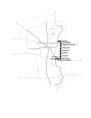
Phase II of Line 204 would extend from Rundle Station in a generally east-by-northeast direction for roughly 1,400 metres before curving to the southeast and south for another 200 metres before surfacing in a streetside right of way along 52 Street NE and arriving at Pineridge Station, where 52 Street intersects 26 Avenue NE. From there, the service would continue on the surface adjacent to 52 Street NE, travelling 1,600 metres to Madigan Drive Station and a further 1,500 metres to Penbrooke Meadows Station, at the intersection with Fifth Avenue SE, before proceeding 1,100 metres south to descend through an underground portal to arrive 200 metres due south at Forest Lawn Station, an underground metro station beneath the junction of 52 Street and 17 Avenue SE. The line would continue 200 metres south before surfacing and proceeding a further 1,400 metres at grade along 52 Street SE to arrive at Erin Woods Station, near 34 Avenue SE, and continuing south another 1,400 metres to Eastfield Station, at the intersection with 48 Avenue SE, and a further 1,300 metres to 61 Avenue Station, before covering an 1,100-metre distance to turn through an underground portal to a surface alignment at 72 Avenue SE and arrive at Great Plains Station. At that point, the line would continue westward 800 metres to Foothills Industrial Station, just west of 44 Street SE, and a further 900 metres to 30 Street Station before crossing the Western Headworks Canal and traversing the CPR Ogden Shops at a grade separation to terminate after a distance of 1,800 metres at an underground interchange with Ogden Station on Line 203.

The total capital investment required for the 52 Street Industrial phase of Line 204 comes to $987-million, a figure that could be carried over thirty years in instalments of $49-million from 2027 onward, or financed through an MSI-equivalent funding mechanism from 2024 to 2026 in three instalments of $329-million. The details of the necessary capital investment are identified as follows:

52 Street Industrial Metro Track and Way of 2.00 km
@ $155-million per km: $310-million
plus two metro stations (Forest Lawn, Ogden)
@ $92-million each: $184-million

52 Street Industrial Surface Track and Way of 11.00 km
@ $25-million per km: $275-million
plus nine surface stations (Pineridge, Madigan Drive, Penbrooke Meadows, Forest Lawn, Erin Woods, Eastfield, 61 Avenue, Great Plains, Foothills Industrial, 30 Street)
@ $10-million each: $ 90-million

Rolling Stock of 32 LRVs (Avanto)
@ $4-million each: $128-million

The second phase of Line 204 greatly increases the connectivity of residential neighbourhoods in eastern Calgary to commercial, residential, and institutional destinations throughout the city, but this is far from the only passenger mobility enhancement deriving from the installation of this new element of the C-Train system. As Roderick Diaz notes in “Impacts of Rail Transit on Property Values”, one key benefit of a light rail line serving an industrial corridor is that commercial and industrial sites located in proximity to mass transit services “experience higher property values because such properties have increased access to a larger labour market” (Diaz, 1999:4). This rise in city-wide labour mobility results in direct and ancillary benefits to industrial employers and to retail operators serving an enlarged labour pool, which as described in “The Calgary Transportation Effect” turns an increased and more efficient transit passenger throughput into “increased retail activities, expanding the attractiveness of the area to commercial investors and retailers” (Campbell et alia, 2007:9). Both of these effects anticipate the overall development and mobility strategy articulated in the “Southeast Industrial Area Structure Plan”, in which “demand for serviced industrial land can be met in an economical manner and in a manner that is responsive to changing market conditions” (City of Calgary, 1996:4). On multiple levels, therefore, using 52 Street E to define the eastern arc of Line 204 is a strategic transportation benefit to C-Train passengers; to residential, commercial, and industrial development in eastern Calgary; and to the city as a whole.

Works Cited

Campbell, Don R.; Reuter, Ray; and Tennant, Melanie (2007). “The Calgary
Transportation Effect: The Impact of Transportation Improvements on Housing Values in Greater Calgary”. URL as of 24 Mar 2008
http://www.realestateinvestingincanada.com/files/calgary_transportation_%20report.pdf

City of Calgary (1996) “Southeast Industrial Area Structure Plan”. URL as of 26 Mar 2008 http://www.calgary.ca/docgallery/bu/planning/pdf/southeast_industrial_asp/southeast_industrial_asp_one.pdf

Diaz, Roderick B. (1999). “Impacts of Rail Transit on Property Values”. URL as of 18 Jul 2008 http://www.apta.com/research/info/briefings/documents/diaz.pdf

17 July 2008

Interlude: Some Downtown C-Train Diagrams


Figured that my Gentle Readers* out there in the blogosphere could use a little respite from densely-worded narratives today in favour of some more diagrams. So here you go.
Starting from how the C-Train's downtown service looked on opening day in May 1981...


...we'll move on to how things look downtown right now, with future platform renovations not yet complete...

...and carry on from there to see how the downtown would look with the north-to-southeast Line 203 and with metro construction on Lines 201 and 202...

...and finish things off with a nice colour shot of how the downtown could look by 2040 with all the LRT service this burg could use in place:


"But what is this?" my Gentle Readers** enquire. "What of this peculiar 'Line 206' of which we've heard nothing at all ever before?"

Stay tuned for a future post answering that very question. Your regularly scheduled light rail development rant is forthcoming very soon.
UPPITY DATE: By special request, the diagrams are now scalable! Woo-hoo!

___________________
* Yes, both of you.
** Like I said, both of you.

16 July 2008

Expanding from a New Model: Line 203 Phase III — 2024

The third and final phase of Line 203 represents both the redemption of a promise to the citizens of northern Calgary and an overture to those who would reside in the city’s southeastern precincts. Extending the Centre Street Metro northward to join the existing Harvest Hills Boulevard right of way north of Beddington Trail will close the gap between Calgary’s downtown core and the nascent and maturing residential communities between Beddington Trail and the planned Symons Valley Parkway near the northern city limits, providing an effective and efficient mass transit option for Calgarians living and working north of the Bow River. At the same time, laying the foundations for Line 203’s southeastern expansion now permits the city to avail itself of an opportunity to integrate light rail transit mobility and development planning from the outset into emerging residential community proposals that draw from higher-density building principles. Fittingly, the completion of Line 203 Phase III will extend the reach of the C-Train to its greatest overall length.

The northward extension of Line 203 would continue underground from Highland Park Station for 1,600 metres beneath Centre Street to arrive at Thorncliffe Station, at the intersection with 56 Avenue and Northmount Drive NW. It would then proceed underground for another 800 metres before surfacing in the existing Centre Street surface right of way north of 64 Avenue NW and arriving after a further distance of 700 metres at a street-level Huntington Hills Station at the intersection with 68 Avenue NW. From there, the line would run at grade for 900 metres before tunnelling under the intersection of Centre Street and Beddington Boulevard a further 400 metres to Beddington Station, midway between Beddington Boulevard and Bergen Road, and 1,000 metres beyond that under Centre Street across Beddington Trail to emerge into the current surface right of way in the median of Harvest Hills Boulevard, leading an additional 600 metres at grade to Aurora Park Station at the intersection with 96 Avenue N. The northward extension of Line 203 would then proceed 700 metres to Harvest Hills Station, at the intersection with Harvest Oak Gate NE, and a further 900 metres across Country Hills Boulevard to Coventry Centre Station, before continuing 700 metres to Panorama Hills Station, at the intersection with Panamount Boulevard NW, and 800 metres to Panatella Gate Station, at the intersection with Panatella Gate NW. To complete the buildout of the Line 203 northward extension, the line would proceed a further 1,800 metres to cross Stoney Trail and arrive at its terminus of Symons Valley Parkway Station, at the intersection of Harvest Hills Boulevard and the Symons Valley Parkway.

In contrast, the southeast extension of Line 203 would be much shorter, extending southeast from Seton Station across Deerfoot Trail for a total length of five kilometres to cross the Bow River adjacent to the 212 Avenue SE right of way and serve several suburban communities in the early planning stages at Jamieson Station, Pine Creek Station, and Walden Station. Although the southeast extension would be designed to operate in a dedicated surface right of way, the formal demarcation of the route would be contingent on formal subdivision and base mapping of the communities being served by this extension.

The total capital investment required for the final buildout of Line 203 comes to $1,222-million, a figure that could be carried over thirty years in instalments of $61-million from 2025 onward, or financed through an MSI-equivalent funding mechanism from 2022 to 2024 in three instalments of $407-million. The details of the necessary capital investment are identified as follows:

Centre Street Metro Track and Way of 2.00 km
@ $155-million per km: $310-million

plus two metro stations (Thorncliffe, Beddington)
@ $92-million each: $184-million

Centre Street Surface Track and Way of 9.00 km
@ $25-million per km: $225-million

plus seven surface stations (Huntington Hills, Aurora Park, Harvest Hills, Coventry Centre, Panorama Hills, Panatella Gate, Symons Valley Parkway)
@ $10-million each: $ 70-million

Southeast Surface Track and Way of 5.00 km
@ $25-million per km: $125-million

plus three surface stations (Jamieson, Pine Creek, Walden)
@ $10-million each: $ 30-million

Aurora Park Yard: $200-million

Rolling Stock of 32 LRVs (Avanto)
@ $4-million each: $128-million

In addition to meeting the immediate light rail service needs of north Calgary residents living in close proximity to Centre Street and to Harvest Hills Boulevard, the buildout of northbound Line 203 presents the opportunity to operate connecting service for the 54,000 residents expected to live in the region defined between 14 Street and Sarcee Trail NW in the Symons Valley Community Plan, which foresees a series of neighbourhood transit nodes “[promoting] transit use and social interaction and [serving] as a gathering place for residents” (City of Calgary, 2001:4). Furthermore, the completion of northbound Line 203 would provide for the accessibility of a major commercial and light industrial development to a truly effective mass transit spine, in accordance with the expectations of the “Aurora Business Park Area Structure Plan” that public transportation “facilitate access from major transit corridors serving commuters living in the surrounding residential communities and working within the Plan area” (City of Calgary, 2008a:33). The buildout of the Line 203 to the southeast will be especially helpful in determining the connectivity and future shape of such proposed residential communities as the Villages of Walden, whose phased higher-density development would be enhanced by the provision of light rail service to a location anticipating 12,000 residents in the first phase alone (City of Calgary, 2007g:4-5). All of these factors speak to the criticality and the strategic import of constructing Line 203 of the C-Train system to its final destinations and boundaries.

Works Cited

City of Calgary (2001). “Symons Valley Community Plan”. URL as of 26 Mar 2008 http://www.calgary.ca/docgallery/bu/planning/pdf/symons_valley_community_plan/symons_valley_cp_oc_one.pdf

City of Calgary (2007g). “Report to Council from Calgary Planning Commission: File LOC2007-0003”. URL as of 26 Mar 2008 http://publicaccess.calgary.ca/lldm01/livelink.exe?func=ccpa.general&msgID=IeyAcAsAKT&msgAction=download&vernum=2

City of Calgary (2008a). “Aurora Business Park Area Structure Plan” URL as of 26 Mar 2008 http://www.calgary.ca/DocGallery/BU/planning/pdf/aurora_asp/aurora_asp.pdf

Expanding from a New Model: Line 204 Phase I — 2023

All of the light rail planning that has occurred to this juncture in Calgary has hewn closely to the radial model of service, wherein mass transit lines intersect in the downtown core to reach out in different directions to suburban locations within the city. There is no dispute to the effectiveness and the necessity of the three radial lines on offer thus far. What is needed as an integral component of a long-term mass transit strategy in Calgary is a means to fill in the gaps in service that a radial network would leave, and to accommodate C-Train passengers whose destinations lie outside the downtown core.

The inspiration for solving this problem dates back to 1896, which is when the Glasgow Subway first entered service in that Scottish city as a six-mile-long steam-powered cable-car loop underneath the city centre and the River Clyde. With an annual ridership in the 13-million-passenger range after its electrification through the 1920s and a three-year closure and renovation of the system from 1977 to 1980, the Glasgow Subway is a high-traffic central circulator that is somewhat constrained by a “reduced scope for full commuting journeys, but modal interchange opportunities provide links to radial routes in the city and beyond” (Strathclyde Partnership for Transport, 2008b). The transfer options for Glasgow Subway patrons range from existing connections to three British Rail stations to future integration by 2021 with a comprehensive network of urban light rail, commuter rail, coastal ferries, and city bus and long-haul motor coach services (Strathclyde Partnership for Transport, 2008a:6-7).

While the Glasgow Subway would influence the integration of orbital and radial metro lines in locations as diverse as Moscow and Miami, perhaps the most helpful example of the sequential implementation of an orbital line comes from Singapore, whose Mass Rapid Transit Circle Line is slated to open in five phases starting in 2009. On its completion in 2020, the Circle Line will consist of 33.3 kilometres of electrified double track and 29 underground stations, with multi-level platform interchanges connecting the new service to key stations on Singapore’s three current radial lines (Land Transportation Authority of Singapore, 2008). In proclaiming that the first phase of the Circle Line would commence revenue service in 2009, Singaporean Transport Minister Raymond Lim indicated that this initial segment would bridge the existing northeastern and northern legs of the municipal mass transit system and lead to a twenty-minute reduction in travel times from those sectors of the city, with additional segments entering service in sequence to meet the objective of “[planning] our land transport system around people, not the other way round” (Government of Singapore, 2008).

From a Calgarian perspective, there are four key criteria that the construction of the first phase of an orbital light rail transit line must satisfy. First and foremost among them is the ability of the line to start from logical transit termini that are scalable to further connections and extensions. Additionally, the line must intersect with existing radial C-Train services at a reasonable directness and with a reasonable economy of passenger travel time between them. Moreover, the line must afford passenger access to destinations that either are not served at all by the current light rail service network or are targets for intensification and expansion that risk overloading the C-Train system without effective relief planning. Finally, the line must complement existing corridors for urban development that presuppose strategic transit investments and presage transit orientation, pedestrian safety, and urban vitality. It is in the service of satisfying these key criteria that Phase I of C-Train Line 204 is being put forward as an effective urban transit solution.

The first phase of Line 204 would consist of a total of 12 kilometres of electrified double track running generally in parallel with 16 Avenue North, of which four kilometres would be built with grade separations for maximum operational efficiency. Starting from a metro interchange with the existing Rundle Station, the line would proceed underground for roughly 400 metres before curving into a surface alignment in the 16 Avenue NE median and continuing a further 600 metres to Mayland Heights Station, adjacent to the intersection with 19 Street NE. The line would then continue westward, crossing the interchange of 16 Avenue and Deerfoot Trail NE on its own elevated span, and proceed in dedicated exclusive light rail lanes adjacent to the renovated 16 Avenue median for a total of 2,400 metres to Renfrew Station, at the intersection with Sixth Street NE. From there, the line would proceed another 300 metres to the surface-level Edmonton Trail Station before entering a metro portal for an interchange with the existing Transcanada Station. The line would surface again to dedicated exclusive light rail lanes and arrive after travelling 400 metres at the surface-level Mount Pleasant Station, where 16 Avenue meets Fourth Street NW, before continuing for a total of 2,400 metres to Rosedale Station, at the intersection of 16 Avenue and Eighth Street NW; to Polytechnic Station, at the intersection with 12 Street NW; to Capitol Hill Station, at the intersection with 16 Street NW; and to the transparently-named 19 Street Station. The remaining 3,600-metre length of the initial phase of Line 204 would continue at separated grades, with a metro tunnel leading to an interchange with the existing Banff Trail Station and continuing from there to an elevated track and platform structure at Stadium Station, to be located between University Drive NW and the western flank of McMahon Stadium, before entering the University Drive median at a sufficient incline to arrive underground at Campus Gate Station, beneath the existing Calgary Transit terminal on the University of Calgary grounds. From that location, the first phase of Line 204 would travel under 24 Avenue NW and arrive at West Campus Station, at the intersection with 37 Street NW, before turning southeast to cross underneath 16 Avenue NW once more and arrive at its final stop at Foothills Medical Station, near the existing Calgary Transit terminal on the hospital grounds.

The total capital investment required for the Transcanada phase of Line 204 comes to $1,872-million, a figure that could be carried over thirty years in instalments of $94-million from 2024 onward, or financed through an MSI-equivalent funding mechanism from 2020 to 2023 in four instalments of $468-million. The details of the necessary capital investment are identified as follows:

Transcanada Metro Track and Way of 4.00 km
@ $155-million per km: $620-million

plus seven metro stations (Rundle, Transcanada, Banff Trail, Stadium, Campus Gate, West Campus, Foothills Medical)
@ $92-million each: $644-million

Transcanada Surface Track and Way of 8.00 km
@ $25-million per km: $200-million

plus eight surface stations (Mayland Heights, Renfrew, Edmonton Trail, Mount Pleasant, Rosedale, Polytechnic, Capitol Hill, 19 Street)
@ $10-million each: $ 80-million

Meridian Park Yard: $200-million

Rolling Stock of 32 LRVs (Avanto)
@ $4-million each: $128-million

With interchange stations at Banff Trail on Line 201, Rundle on Line 202, and Transcanada on Line 203, the first phase of Line 204 meets the critical objective of bridging the C-Train system’s radial lines and allowing for passenger network effects that otherwise would not be available. It is also worth noting the capacity improvements and the passenger flow redistribution opportunities at the University of Calgary, McMahon Stadium, SAIT Polytechnic, and the Sunridge Mall – Peter Lougheed Hospital initial terminal complex that the Transcanada phase of Line 204 would afford, as well as the further extension of C-Train service connections to the Foothills Medical Centre initial terminus and the West Campus of the University Lands. The Transcanada phase also supports such key urban redevelopment activities as the “Sixteenth Avenue North Urban Corridor Area Redevelopment Plan”, a statutory policy document envisaging a “necklace” of residential and commercial development nodes that “are expected to create a critical mass at these locations that will promote pedestrian activity and business viability” (City of Calgary, 2007h:6). As a response to the call for passenger mobility improvements across Calgary’s breadth, the Transcanada phase of Line 204 meets every key immediate objective and permits further strategic expansion of the C-Train network.
Works Cited
City of Calgary (2007h). “Sixteenth Avenue North Urban Corridor Area Redevelopment Plan”. URL as of 26 Mar 2008 http://www.calgary.ca/docgallery/bu/planning/pdf/sixteen_avenue_north_study/sixteen_avenue_north_study_one.pdf
Government of Singapore (2008). “Speech by Mr Raymond Lim, Minister for Transport, at the Visit to Kim Chuan Depot, 25 January 2008, 9.00 AM: Doubling Our Rail Network”. URL as of 15 Jul 2008 https://app-pac.mica.gov.sg/data/vddp/embargo/6260896.htm
Land Transport Authority of Singapore (2008). “Circle Line”. URL as of 15 Jul 2008 http://www.lta.gov.sg/projects/proj_rail_ccl.htm
Strathclyde Partnership for Transport (2008a). “A Catalyst for Change: The Regional Transport Strategy for the West of Scotland, 2008-21”. URL as of 15 Jul 2008 http://www.spt.co.uk/rts/documents/catalyst_for_change.pdf

Strathclyde Partnership for Transport (2008b). “SPT Subway: Facts and Figures”. URL as of 15 Jul 2008
http://www.spt.co.uk/subway/facts.html

10 July 2008

Expanding from a New Model: Line 203 Phase II — 2021


The two regions of Calgary whose needs for light rail transit service will remain most pressing with the buildout of Lines 201 and 202 will be the northern and southeastern sectors of the city. Both of these areas share several points in common, among them a mixture of residential and industrial development, a fusion of old Calgary and new suburbia, and a transportation network that with the rapid growth of the city’s population has become increasingly congested and constrained. The key point on which the northern and southeastern sectors differ is the interest that has been shown thus far in serving their respective residents and employees with effective light rail solutions.

Perhaps the most telling example of Calgary Transit’s left hand not knowing what its right hand is doing is the difference in vision for a city of 1.25-million between mass transit service proposals for the northern and southeastern sectors of the city. Light rail transit is identified as a necessity from Inglewood to the far reaches of southeast Seton in a 2005 Calgary Transit report on the basis of a service population of 184,000, employment of 107,000 (Calgary Transit, 2005:3), and the active implementation of transit-orientated development, particularly “at stations located north of Glenmore Trail” en route to the downtown core, as a means of enhancing daily ridership by 22 percent over what could be achieved merely through building the southeast leg of C-Train Line 203 (2005:4). Even the substantial capital investment necessary for the Eau Claire Metro (Clifton ND Lea et alia, 2006:6) is not enough to deter the long-range planning for the southeast leg of the C-Train system.

In that context, it might strike observers as odd that Calgary Transit’s “North Central Calgary Transit Corridor Review” (2006c), filed a mere 13 months later, makes no mention whatsoever of transit-orientated development. These observers might also find it peculiar that the authors of the report make plain their opinion of the 119,000 residents (2006c:9) and 36,700 employees (2006c:11) located within one mile of Centre Street North between Beddington Trail and the Bow River — accounting for 48 percent of the residential base and 64 percent of the employment base in the projected North Calgary service area at the 1.25-million population horizon (2006c:8) — in their argument that because the outlying northern reaches of the city are expected to generate 3,900 of a possible 7,000 peak hour passengers per hour (2006c:17), and because “a central, north/south route suitable for LRT service is not readily available” (2006c:24), the north-central leg of the C-Train might as well be built along the Nose Creek Valley in spite of “limited opportunities to provide access to the line” (2006c:26). Such simple building blocks for building cities as metro construction, streetscaping, transit-orientated development, and the creation of a vital and pedestrian-friendly retail and residential environment along Centre Street all fall by the wayside in a putative vision that most observers would have great difficulty actually discerning, due in no small measure to a poverty of institutional imagination in which the inner neighbourhoods of Centre Street, petrified in amber, make their own way in isolation from the rest of Calgary “by the existing combination of [bus rapid transit], mainline, and express bus services” (2006c:26).

It is in the spirit of correcting this disparity in civic vision that a new solution for building the second phase of Line 203 becomes obvious. On one level, this new second phase is all about building on what has previously come to fruition, most apparently in terms of the southeast extension of the line from Douglasdale to Seton, but most importantly in terms of using the Phase I terminus at Eau Claire as a gateway to northbound service. When one investigates the strategy more closely, however, the Centre Street Metro that is the linchpin of northbound Line 203 is more than a tool for investing in the value proposition of the line — it is a tool for investing in the value proposition of Centre Street itself as a magnet for people, business, industry, and sustainable development in close and accessible proximity to Calgary’s core.

The most complex element of the Centre Street Metro would be its initial 900-metre extension from the completed Eau Claire Station, from which a tunnel would proceed underneath the Bow River, Prince’s Island, and Memorial Drive, rising slightly through a portal beneath the intersection of Crescent Road and Centre A Street NW before curving underneath Centre Street at an approximate 25-metre depth to arrive at Crescent Heights Station, at the intersection with Eighth Avenue NW. From that point, the Centre Street Metro would rise slightly, continuing another 900 metres to arrive at Transcanada Station, 15 metres deep at the junction of Centre Street and 17 Avenue NW. At a further distance of 1,000 metres would come Tuxedo Park Station, ten metres deep at the intersection of Centre Street and 28 Avenue NW. The initial phase of the Centre Street Metro would end 1,200 metres northward at Highland Park Station, where Centre Street meets 40 Avenue NW.

Conversely, almost all of the southeast extension of Line 203 from Douglasdale Station would be accommodated on existing surface rights of way (Calgary Transit, 2005:2). The first segment of this extension would proceed for 3,400 metres in surface corridors paralleling 114 Avenue SE and 40 Street SE to arrive at Shepard Station, near the intersection of 126 Avenue and 48 Street SE. From there, the extension would enter a surface corridor adjacent to 52 Street SE, travelling 1,400 metres to Prestwick Station, where 52 Street meets Prestwick Gate SE, and a further 1,200 metres to McKenzie Towne Station, where McKenzie Towne Link SE. The southeast extension would proceed an additional 2,700 metres along 52 Street, crossing Highway 22X through a grade-separated portal before arriving at Auburn Bay Station, approximately at the intersection of 52 Street and 178 Avenue SE. After continuing 1,800 metres along 52 Street SE, this phase of the southeast extension of Line 203 would turn east through an underground portal to surface and arrive a further 200 metres along at Hospital Station, at the intersection of 45 Street and Front Street SE, before curving southward once more to end after 800 metres at Seton Station.

The total capital investment required for the Phase II extension of Line 203 comes to $1,642-million, a figure that could be carried over thirty years in instalments of $82-million from 2022 onward, or financed through an MSI-equivalent funding mechanism from 2018 to 2021 in four instalments of $411-million. The details of the necessary capital investment are identified as follows:

Centre Street Metro Track and Way of 4.80 km
@ $155-million per km: $744-million
plus four metro stations (Crescent Heights, Transcanada, Tuxedo Park, Highland Park)
@ $92-million each: $368-million


Southeast Surface Track and Way of 11.20 km
@ $25-million per km: $280-million
plus 0.40 km underpass
@ $155-million per km: $ 62-million
plus six surface stations (Shepard, Prestwick, McKenzie Towne, Auburn Bay, Hospital, Seton)
@ $10-million each: $ 60-million

Rolling Stock of 32 LRVs (Avanto)
@ $4-million each: $128-million

The completion of this second phase of Line 203 would allow for the immediate capture of 31,700 passengers per day between McKnight Boulevard and the Bow River, representing the 76 percent of the total daily ridership in 2005 of 41,500 (Calgary Transit, 2006c:15) that as of 2005 resided within one mile of Centre Street North between Beddington Trail and the Bow River (2006c:9), as well as for the immediate increase in capture to 46,200 passengers per day along the whole of the southeast leg of Line 203 (Calgary Transit, 2005:5). Transit-orientated development along the southeast leg of Line 203 would generate an additional 10,000 daily passengers (2005:5), with a further 10,000 daily passengers being feasible in conjunction with redevelopment on Centre Street as well.


Works Cited

Calgary Transit (2005). “Southeast LRT: Future Population, Employment and Ridership”. URL as of 20 Mar 2008 http://publicaccess.calgary.ca/lldm01/livelink.exe?func=ccpa.general&msgID=QKTTqrsqqA&msgAction=download&vernum=1

Calgary Transit (2006c). “North Central Calgary Transit Corridor Review”. URL as of 25 Mar 2008 http://www.calgarytransit.com/pdf/north_central_calgary_transit_corridor_review.pdf

Clifton ND Lea et alia (2006). “Southeast LRT Functional Planning Study, Phase III: Glenmore Trail to Elbow River”. URL as of 26 Mar 2008 http://www.calgarytransit.com/pdf/SE_LRT_Final_Report.pdf